Title: Map of Kansas, Nebraska and Colorado.
Content Date: 1863
Copyright Date: 1861
Author: Gamble, W. H.
Publisher: S. Augustus Mitchell
Size: 29 x 36 cm
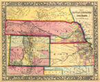
Description: Includes topographic features.Indicates locations of forts.Identifies Santa Fe Trail as Santa Fe Route.Shows Pony Express Route.Indicates Native American inhabitation.Removed from unknown source with page number 43.Archaic county names and boundaries.Shows railroad lines.
Call Number: 1863-0002