Title: Colton's Map of Kansas, Nebraska, Dakota & Indian Territory.
Content Date: 1866
Publisher: G. W. and C. B. Colton & Co.
Size: 67 x 42 cm
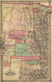
Description: Includes topographic features.Indicates locations of forts.Shows route of Captain J. C. Fremont, Major W. H. Emory, Lieut. I. G. Woodruff and Lieut. W. G. Peck.Indicates Native American inhabitation.Removed from unknown source with page numbers 65 and 66.Verso: The State of Iowa. State of Kansas, and Nebraska, and Indian Territories.Archaic county names and boundaries in Kansas.Shows railroad lines, including Southern Route to Denver City.
Call Number: 1866-0002