Title: Map of Arkansa and other territories of the United States
Content Date: 1822
Author: Long, Stephen Harriman
Size: 37 x 38 cm
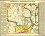
Description: First map to designate the Great American Desert.Includes topographic features.Indicates location of forts.Shows routes for Major Stephen Long, Lt. Andrew Talcott, Exploring Expedition, and Captain Bell.Indicates Native American inhabitation.Includes text on both left and right side margins of map describing the Arkansas Territory.At head of title: Geographical, Statistical and Historical Map of Arkansas TerritoryRemoved from Henry Charles Carey's A Complete Historical, Chronological and Geographical American Atlas, map No. 35.
Call Number: 1822-0002