Title: Maps showing the Route and Land Grant of the Missouri Kansas & Texas Railway and its Principal Connecting Lines.
Content Date: 1871
Publisher: G. W. & C. B. Colton & Co.
Size: 64 x 54 cm
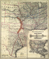
Description: Hand colored.Includes topographic features.Indicates locations of forts.Indicates Native American inhabitation.Inset map of United States showing railroads.Archaic county names and boundaries in Kansas.Shows Missouri, Kansas & Texas Railway and other unnamed lines.Shows limits of land grant for Missouri, Kansas & Texas Railway.Shows canals.
Call Number: 1871-0005