Title: Kansas, Nebraska, Colorado, Dakota, Wyoming and Part of Montana, with Manitoba.
Content Date: 1873
Author: Bartholomew, J.
Publisher: T. Ellwood Zell
Size: 29 x 21 cm
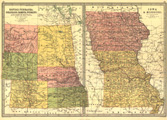
Description: Includes topographic features.Indicates locations of forts.Indicates Native American inhabitation.On same sheet with page number 12: Map of Iowa & Missouri.Possibly removed from Zell's Descriptive Hand Atlas of the World with page numbers 13.Archaic county names and boundaries in Kansas.Shows unnamed railroad lines.
Call Number: 1873-0002