Title: County map of Kansas, Nebraska, Colorado, Utah and Wyoming.
Content Date: 1874
Corporate Author: H. H. Lloyd & Co.
Size: 35 x 57 cm
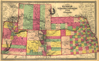
Description: Includes topographic features.Indicates locations of forts.Indicates Native American inhabitation.Possibly removed from H. H. Lloyd & Co.'s Atlas of the United States with page numbers 76 and 77.Archaic county names and boundaries.Shows Kansas Pacific Railroad and other unnamed railroad lines.
Call Number: 1874-0002