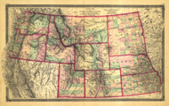
Title: Map of the North Western States and Territories. Including Kansas, Nebraska, Dakota, and Region West to the Pacific Ocean.
Content Date: 1874
Publisher: Taintor Bros. & Merrill
Size: 48 x 79 cm
Description: Includes topographic features.Indicates locations of forts.Shows locations of missions.Indicates Native American inhabitation.Removed from unknown source with page numbers XXXIV and XXXV.Archaic county names and boundaries in Kansas.Shows unnamed railroad lines.
Call Number: 1874-0004