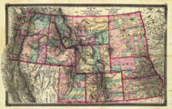
Title: Map of the North Western States and Territories. Including Kansas, Nebraska, Dakota, and Region West to the Pacific Ocean.
Content Date: 1874
Publisher: Taintor Bros. & Merrill
Size: 48 x 74 cm
Description:
 Includes topographic features.
 Indicates locations of forts.
 Shows locations of missions.
 Indicates Native American inhabitation.
 Map cover title: Taintor's Pocket Maps: Kansas, Nebraska, Colorado, Wyoming and Dakota.
 Includes page numbers XXXIV and XXXV.
 Archaic county names and boundaries in Kansas.
 Shows unnamed railroad lines.


Call Number: 1874-0005

