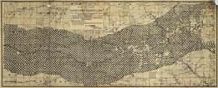
Title: Map of Part of the Kansas Pacific Railway Lands
Content Date: 1876
Publisher: Kansas Pacific Railway (?)
Size: 33 x 83 cm
Description: Includes topographic features.Indicates locations of forts.Archaic county names and boundaries.Shows Kansas Pacific Railroad; Missouri, Kansas & Texas Railroad; Junction City & Ft. Kearney Railroad; and Manhattan & Northeastern Railroad.Text below title refers to the Centennial of the United States.Indicates railway lands sold and for sale.Indicates government lands homesteaded and available for homesteading.Shows limits of land grant for Kansas Pacific Railway.Includes township names.
Call Number: 1876-0003