Title: Map of the Indian tribes of North America about 1600 A.D. along the Atlantic & about 1800 A.D. westwardly
Content Date: 1836
Author: Gallatin, Albert
Publisher: American Antiquarian Society
Size: 38 x 41 cm
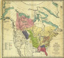
Description: First map to show a detailed geography of the American west.Hand colored.Includes topographic features.Includes route for Jedediah B. Smith, early trader and explorer.Indicates Native American inhabitation.Removed from Gallatin's "A Synopsis of the Indian tribes within the United States East of the Rocky Mountains and in British and Russian Possessions in North America" found in Transactions and Collections of the American Antiquarian Society, vol. II of Archaeologica Americana.
Call Number: 1836-0001