Title: Map Illustrating the plan of the defences of the Western and North-Western Frontier, as proposed by Charles Gratiot, in his report of Oct. 31, 1837.
Content Date: 1837
Author: Hood, Washington
Other Author(s): Gratiot, Charles. Abert, John James.
Publisher: Bowen & Co.
Size: 54 x 39 cm
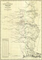
Description: Map was drawn to illustrate a bill to authorize the President to occupy the Oregon Territory.Includes topographic features.Indicates military forts.Indicates Native American inhabitation.Includes table showing distances and days marches between forts.Upper right: 2nd session, 25th Congress, S. No. 1. Document 65.
Call Number: 1837-0002