Title: A map of the Indian Territory, Northern Texas and New Mexico showing the Great Western Prairies
Content Date: 1844
Author: Gregg, Josiah
Publisher: Sidney E. Morse and Samuel Breese
Size: 31 x 38 cm
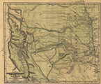
Description: First map to carefully display the Llano Estacado or Staked Plain of Texas.Hand colored.Includes topographic features.Indicates locations of forts, military roads and trading posts.Includes routes of Captain Nathan Boone, Major Stephen Long, Captain Zebulon Pike, Texan Santa Fe Expedition, Colonel Phillip St. George Cooke, and Josiah Gregg.Identifies Santa Fe Trail as Santa Fe Caravans route.Shows Oregon Trail identified as Route of the Oregon Emigrants.Indicates Native American inhabitation.Removed from Josiah Gregg's Commerce of the Prairies.
Call Number: 1844-0002