Title: Phelps's national map of the United States, a traveller's guide. Embracing the principal rail roads, canals, steam boat & stage routes, throughout the Union.
Content Date: 1845
Author: Atwood, John M.
Other Author(s): Phelps, Humphrey
Publisher: Ensigns & Thayer
Size: 54 x 64 cm
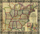
Description: Hand colored.Includes topographic features.Indicates locations of forts.Identifies Santa Fe Trail as Traders route to Santa Fe.Indicates Native American inhabitation.Inset maps: N. part of Maine, Vicinity of Philadelphia, Vicinity of Baltimore, Vicinity of New York, Vicinity of Boston, Southern part of Florida.Inset maps of Pittsburg, St. Louis, Chicago, Cincinnati.Includes illustrated border with portraits of historical figures and state seals.Indicates state capitals, canals and railroads.
Call Number: 1845-0001