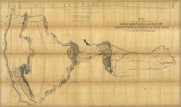
Title: Map of an exploring expedition to the Rocky Mountains in the 1842 and to Oregon & north California in the years 1843-44
Content Date: 1845
Author: Frémont, John Charles
Other Author(s): Abert, John James
Publisher: United States Senate
Size: 76 x 130 cm
Description: First published map to show the entire area west of the Mississippi as seen by a single party.Includes topographic features.Indicates locations of forts.Indicates Native American inhabitation.Has scale at top of map which shows height of mountains including Rockies, Cascades and Sierra Nevadas.
Call Number: 1845-0003