Title: A new map of Texas, Oregon and California with the regions adjoining, compiled from the most recent authorities
Content Date: 1846
Copyright Date: 1925
Author: Mitchell, S. Augustus
Other Author(s): Burroughs, H. N.
Publisher: North Pacific Bank Note Co.
Size: 48 x 45 cm
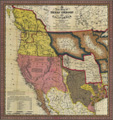
Description: Includes topographic features.Indicates the locations of forts.Shows the trails and routes identified as the Great Spanish Trail from P. Angelos (Pueblo de los Angelos, now Los Angeles) to Santa Fe, Lewis and Clarkes (sic) route and Frémont's route.Indicates Native American inhabitation.Designates Oregon Trail as Oregon route on map and Emigrant Route from Missouri to Oregon in table of distances.Identifies Santa Fe Trail as Caravan route to Santa Fe.
Call Number: 1846-0002