Title: Carte de la Louisiane et du Cours de Mississippi
Content Date: 1718
Author: L'Isle, Guillaume de
Size: 49 x 65 cm
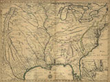
Description: Early map to show the western region of the country as far as the course of the upper Rio Grande.Hand colored.Includes topographic features.Includes various routes of early explorers.Indicates Native American inhabitation.Inset map: Carte Particuliere des Embouchures de la Rivie S Louis et de la Mobile.Removed from unknown source with manuscript page number 212.
Call Number: 1718-0001