Title: Map of the United States and their territories between the Mississippi and Pacific Ocean, and part of Mexico.
Content Date: 1850
Corporate Author: Bureau of the Corps of Topographical Engineers, Sherman and Smith.
Size: 108 x 97 cm
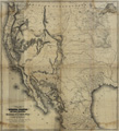
Description: Map shows a synthesis of the many and varied cartographic activities of the U. S. Army in the West since the onset of the Mexican War.Includes topographic features.Indicates locations of forts and missions.Indicates unnamed trails and routes.Indicates Native American inhabitation.
Call Number: 1850-0003