Title: A New Map of the United States. Upon which are delineated its vast works of Internal communication, routes across the continent &c. Showing also Canada and the Island of Cuba.
Content Date: 1854
Copyright Date: 1854
Author: Williams, W.
Size: 62 x 75 cm
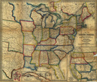
Description: Hand colored.Includes topographic features.Indicates locations of forts.Shows Pawnee Trail, J. C. Fremont's Route, Lieut. W. H. Whiting's Route and various other routes.Identifies Santa Fe Trail as Trader's Route from Independence Mo. to Santa Fe.Shows Oregon Trail identified as Oregon Route and as Route from Independence Mo. to Oregon via South Pass.Indicates Native American inhabitation.Inset maps: Map of California, Oregon, New Mexico, Utah &c., Map of the Island of Cuba, City & Harbor of Havana, Map of the Niagara River and Falls.Shows railroads, canals, common roads, swamps, and railroads in progress.
Call Number: 1854-0008