Title: Township map of Kansas compiled from the U. S. Surveys and actual Observation
Content Date: 1856
Author: Propper, George N.
Corporate Author: Middleton, Wallace & Co.
Publisher: E. Mendenhall
Size: 47 x 68 cm
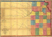
Description: Hand colored.Includes topographic features.Indicates locations of forts.Shows Oregon Trail.Identifies Santa Fe Trail as Santa Fe & California Trail.Indicates Native American inhabitation.Archaic county names and boundaries.Shows emigrant roads and common roads.Shows railroad routes identified as Manhattan and Leavenworth Rail Road Route and Pacific Rail Road.
Call Number: 1856-0011