Title: Map Showing the progress of the Public Surveys in the territories of Kansas and Nebraska To accompany Annual Report of the Surveyor General. 1857.
Content Date: 1857
Author: Calhoun, J.
Corporate Author: Wagner & McGuigan, Lith.
Publisher: Surveyor General's Office
Size: 60 x 44 cm
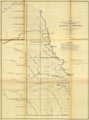
Description: Includes topographic features.Indicates locations of forts.Identifies Santa Fe Trail as Santa Fe and Westport Road.Indicates Native American inhabitation.Shows boundary lines between Kansas and Nebraska and the southern boundary of Kansas.Upper right margin: Sen. Ex. Doc. No. 11 & Ho. Ex. Doc. No. 2 - 1st Sess. 35th Cong.At head of title: (3.)
Call Number: 1857-0001