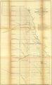
Title: Map Showing the progress of the Public Surveys in the territories of Kansas and Nebraska. To accompany Annual Report of the Surveyor General, 1858.
Content Date: 1858
Author: Burnett, Ward B.
Other Author(s): Graham, C. B., Lith.
Corporate Author: United States Surveyor General
Size: 59 x 37 cm
Description: Includes topographic features.Indicates locations of forts.Indicates Native American inhabitation.Upper left margin: Sen. Ex. Doc. No. 1, Ho. Ex. No. 2, 2nd Sess. 35th Con.At head of title: (4)
Call Number: 1858-0002