Title: J. H. Colton's Map of Missouri and Kansas.
Content Date: 1859
Author: Colton, J. H.
Size: 20 x 27 cm
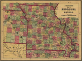
Description: Hand colored.Includes topographic features.Indicates locations of forts.Shows route of Topographical Engineers, 1853.Shows Pony Express Route.Indicates Native American inhabitation.Removed from unknown source with page number 17.Archaic county names and boundaries in Kansas.Shows railroads.
Call Number: 1859-0003