Title: Cram's Rail Road & Township Map of Kansas
Content Date: 1880
Copyright Date: 1878
Publisher: Geo. F. Cram
Size: 40 x 53 cm
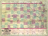
Description: Includes topographic features.Indicates locations of forts.Indicates Native American inhabitation.Archaic county names and boundaries.Shows Atchison, Topeka & Santa Fe Railroad; Kansas Pacific Railroad; Leavenworth, Lawrence & Galveston Railroad; Missouri River, Ft. Scott & Gulf Railroad; Missouri, Kansas & Texas Railroad; St. Joseph & Denver City Railroad; Central Branch of Union Pacific Railroad; and other unnamed lines.
Call Number: 1880-0002