|
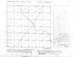
Title: |
Township No. 28 South Range No. 1 West 6 Principal Meridian Kan
|
| Contributor: |
Surveyor General's Office
|
| Creator: |
Special Collections and University Archives, WSU Libraries
|
| Subject: |
Public lands -- Kansas -- Maps, manuscript
|
| Date Created: |
1868
|
| Date Issued: |
2005
|
| Type: |
image
|
| Description: |
Map of Township 28 South Range 1 West of the 6th Principal Meridian, Kansas. Shows Cowskin Creek. Also identified is "Trail to the Indian Territory."
A PDF version is available for downloading and printing.
Current name: Waco Township.
|
|
Identifier: |
images/survey_access/t28s-r1w.1.jpg
|
|
|
|
|
|
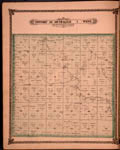
Title: |
Map of Township 28 South Range 1 West. Of the 6th Principal Meridian. Scale: 2 inches to 1 mile.
|
| Contributor: |
Edwards, John P.
|
| Creator: |
Special Collections and University Archives, WSU Libraries
|
| Subject: |
Sedgwick County (Kan.) -- Maps
|
| Date Created: |
1882
|
| Date Issued: |
2006
|
| Type: |
image
|
| Description: |
Map of Township 28 South Range 1 West, Sedgwick County, Kansas. Page 40 of 1882 Historical Atlas of Sedgwick County, Kansas. Shows Big Slough, Dry Creek and Cowskin Creek. Also noted are roads, residences and other structures, schools, wind mill, prope
A PDF version is available for downloading and printing.
Current name: Waco Township.
|
|
Identifier: |
images/atlas_access/t28s.r1w.40.jpg
|
|
|
|
|