|
Title: |
Township No. 28 South Range No. 4 West 6 Principal Meridian Kan.
|
| Contributor: |
Surveyor General's Office
|
| Creator: |
Special Collections and University Archives, WSU Libraries
|
| Subject: |
Public lands -- Kansas -- Maps, manuscript
|
| Date Created: |
1868
|
| Date Issued: |
2005
|
| Type: |
image
|
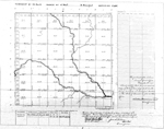
| Description: |
Map of Township 28 South Range 4 West of the 6th Principal Meridian, Kansas. Shows north fork and south fork of "Ne-Ne Squaw" River (Ninnescah River) and unnamed creeks.
A PDF version is available for downloading and printing.
Current name: Morton Township.
|
|
Identifier: |
images/survey_access/t28s-r4w.1.jpg
|
|
|
|
|
|
Title: |
Map of Township 28 South Range 4 West. Of the 6th Principal Meridian. Scale: 2 inches to 1 mile.
|
| Contributor: |
Edwards, John P.
|
| Creator: |
Special Collections and University Archives, WSU Libraries
|
| Subject: |
Sedgwick County (Kan.) -- Maps
|
| Date Created: |
1882
|
| Date Issued: |
2006
|
| Type: |
image
|
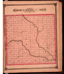
| Description: |
Map of Township 28 South Range 4 West, Sedgwick County, Kansas. Page 57 of 1882 Historical Atlas of Sedgwick County, Kansas. Shows Ninnescah River, southwest fork of Ninnescah River, Mud Creek, Spring Creek and unnamed creeks. Western boundary labeled
A PDF version is available for downloading and printing.
Current name: Morton Township.
|
|
Identifier: |
images/atlas_access/t28s.r4w.57.jpg
|
|
|
|
|