|
Title: |
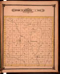
Map of Township 29 South Range 1 West. Of the 6th Principal Meridian. Scale: 2 inches to 1 mile.
|
| Contributor: |
Edwards, John P.
|
| Creator: |
Special Collections and University Archives, WSU Libraries
|
| Subject: |
Sedgwick County (Kan.) -- Maps
|
| Date Created: |
1882
|
| Date Issued: |
2006
|
| Type: |
image
|
| Description: |
Map of Township 29 South Range 1 West, Sedgwick County, Kansas. Page 41 of 1882 Historical Atlas of Sedgwick County, Kansas. Shows Spring Creek and unnamed creeks. Shows Ohio Center post office. Also noted is "Lone Cottonwood" tree in southwest quart
A PDF version is available for downloading and printing.
Current name: Ohio Township.
|
|
Identifier: |
images/atlas_access/t29s.r1w.41.jpg
|
|
|
|
|