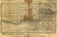
Title: Latest and best Map of Kansas, from authentic sources. Drawn and Engraved, 1881, expressly for the Land Department of the Atchison, Topeka and Santa Fe Railroad
Content Date: 1881
Corporate Author: Matthews, Northrup & Co., Engrvs. & Prs.
Publisher: Atchison, Topeka & Santa Fe Railroad
Size: 28 x 51 cm
Description: Includes topographic features.Indicates locations of forts.Indicates Native American inhabitation.Verso includes information about Kansas.Archaic county names and boundaries.Shows Atchison, Topeka & Santa Fe Railroad; Kansas Division of Union Pacific Railroad; Cowley, Sumner & Ft. Smith Railroad; Florence Eldorado & Walnut Valley Railroad; Lawrence & Southern Kansas Railroad; Kansas City, Lawrence & Southern Kansas Railroad; Kansas, Ft. Scott & Gulf Railroad; Missouri Pacific Railroad; Kansas City, Burlington & Kansas Railroad; Kansas City, Topeka & Western Railroad; Missouri, Kansas & Texas Railroad; Burlington & Missouri River Railroad; Republican Valley Railroad; Central Branch of Union Pacific Railroad; and other unnamed lines.Archaic spelling of El Dorado.
Call Number: 1881-0005
 |