
|
Title: |
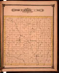
Map of Township 29 South Range 2 East. Of the 6th Principal Meridian. Scale: 2 inches to 1 mile.
|
| Creator: |
Edwards, John P.
|
| Source: |
Historical Atlas of Sedgwick County, Kansas
|
| Repository: |
Special Collections and University Archives, WSU Libraries
|
| Subject: |
Sedgwick County (Kan.) -- Maps
|
| Original Date: |
1882
|
| Digital Date: |
2006
|
| Description: |
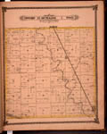
Map of Township 29 South Range 2 East, Sedgwick County, Kansas. Page 34 of 1882 Historical Atlas of Sedgwick County, Kansas. Shows Arkansas River, Pole Cat Creek, Spring Creek and Dog Creek. Eastern boundary labeled Butler County line. Southern boundary labeled Sumner County line. Shows northern portion of town of Mulvane. Shows Atchison, Topeka and Santa Fe Railroad. Also noted are schools, wind mill, roads, residences and other structures, property divisions and names of land owners.
Current name: Rockford Township.
|
|
Print Version: |
A PDF version is available for downloading and printing.
|
|
Identifier: |
images/atlas_access/t29s.r2e.34.jpg
|
|
|
|
|

|
Title: |
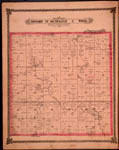
Mulvane Scale 400 Feet to the Inch
|
| Creator: |
Edwards, John P.
|
| Source: |
Historical Atlas of Sedgwick County, Kansas
|
| Repository: |
Special Collections and University Archives, WSU Libraries
|
| Subject: |
Sedgwick County (Kan.) -- Maps
|
| Original Date: |
1882
|
| Digital Date: |
2006
|
| Description: |
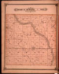
Map, Mulvane, Kansas. Page 35 of 1882 Historical Atlas of Sedgwick County, Kansas. Plat map shows subdivisions, some structures, land ownership, street names, roads, county lines, railroad, and north boundary line of Osage Diminished Reservation.
Current name: Mulvane Township.
|
|
Print Version: |
A PDF version is available for downloading and printing.
|
|
Identifier: |
images/atlas_access/Mulvane.35.jpg
|
|
|
|
|
|
Title: |
Map of Township 25 South Range 1 West. Of the 6th Principal Meridian. Scale: 2 inches to 1 mile.
|
| Creator: |
Edwards, John P.
|
| Source: |
Historical Atlas of Sedgwick County, Kansas
|
| Repository: |
Special Collections and University Archives, WSU Libraries
|
| Subject: |
Sedgwick County (Kan.) -- Maps
|
| Original Date: |
1882
|
| Digital Date: |
2006
|
| Description: |
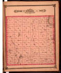
Map of Township 25 South Range 1 West, Sedgwick County, Kansas. Page 37 of 1882 Historical Atlas of Sedgwick County, Kansas. Shows Arkansas River, Little Arkansas River, Jester Creek and unnamed creeks. Shows schools, wind grist mill, roads, residences and other structures, property divisions and names of land owners. Eastern boundary labeled as 6th Principal Meridian. Northern boundary labeled as Harvey County line. Shows towns of Sedgwick and Valley Center. Shows Atchison, Topeka and Santa Fe railroad.
Current name: Valley Center Township.
|
|
Print Version: |
A PDF version is available for downloading and printing.
|
|
Identifier: |
images/atlas_access/t25s.r1w.37.jpg
|
|
|
|
|
|
Title: |
Map of Township 26 South Range 1 West. Of the 6th Principal Meridian. Scale: 2 inches to 1 mile.
|
| Creator: |
Edwards, John P.
|
| Source: |
Historical Atlas of Sedgwick County, Kansas
|
| Repository: |
Special Collections and University Archives, WSU Libraries
|
| Subject: |
Sedgwick County (Kan.) -- Maps
|
| Original Date: |
1882
|
| Digital Date: |
2006
|
| Description: |
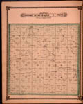
Map of Township 26 South Range 1 West, Sedgwick County, Kansas. Page 38 of 1882 Historical Atlas of Sedgwick County, Kansas. Shows Arkansas River and islands, Little Arkansas River, lake and springs. Also shows schools, wind mill, church, roads, residences and other structures, property divisions and names of land owners. Also noted is Ferris post office. Shows north boundary of Osage Indian Lands.
Current name: Park Township.
|
|
Print Version: |
A PDF version is available for downloading and printing.
|
|
Identifier: |
images/atlas_access/t26s.r1w.38.jpg
|
|
|
|
|
|
Title: |
Map of Township 27 South Range 1 West. Of the 6th Principal Meridian. Scale: 2 inches to 1 mile.
|
| Creator: |
Edwards, John P.
|
| Source: |
Historical Atlas of Sedgwick County, Kansas
|
| Repository: |
Special Collections and University Archives, WSU Libraries
|
| Subject: |
Sedgwick County (Kan.) -- Maps
|
| Original Date: |
1882
|
| Digital Date: |
2006
|
| Description: |
Map of Township 27 South Range 1 West, Sedgwick County, Kansas. Page 39 of 1882 Historical Atlas of Sedgwick County, Kansas. Eastern boundary labeled as 6th Principal Meridian. Shows Arkansas River, Cowskin Creek and Big Slough. Shows wind mills, cemetery, schools, roads, residences and other structures, property divisions and names of land owners.
Current name: Delano Township.
|
|
Print Version: |
A PDF version is available for downloading and printing.
|
|
Identifier: |
images/atlas_access/t27s.r1w.39.jpg
|
|
|
|
|
|
Title: |
Map of Township 28 South Range 1 West. Of the 6th Principal Meridian. Scale: 2 inches to 1 mile.
|
| Creator: |
Edwards, John P.
|
| Source: |
Historical Atlas of Sedgwick County, Kansas
|
| Repository: |
Special Collections and University Archives, WSU Libraries
|
| Subject: |
Sedgwick County (Kan.) -- Maps
|
| Original Date: |
1882
|
| Digital Date: |
2006
|
| Description: |
Map of Township 28 South Range 1 West, Sedgwick County, Kansas. Page 40 of 1882 Historical Atlas of Sedgwick County, Kansas. Shows Big Slough, Dry Creek and Cowskin Creek. Also noted are roads, residences and other structures, schools, wind mill, property divisions and names of land owners.
Current name: Waco Township.
|
|
Print Version: |
A PDF version is available for downloading and printing.
|
|
Identifier: |
images/atlas_access/t28s.r1w.40.jpg
|
|
|
|
|
|
Title: |
Map of Township 29 South Range 1 West. Of the 6th Principal Meridian. Scale: 2 inches to 1 mile.
|
| Creator: |
Edwards, John P.
|
| Source: |
Historical Atlas of Sedgwick County, Kansas
|
| Repository: |
Special Collections and University Archives, WSU Libraries
|
| Subject: |
Sedgwick County (Kan.) -- Maps
|
| Original Date: |
1882
|
| Digital Date: |
2006
|
| Description: |
Map of Township 29 South Range 1 West, Sedgwick County, Kansas. Page 41 of 1882 Historical Atlas of Sedgwick County, Kansas. Shows Spring Creek and unnamed creeks. Shows Ohio Center post office. Also noted is "Lone Cottonwood" tree in southwest quarter of section 26. Southern boundary labeled as Sumner County line. Shows schoos, fish pond, cemetery, roads, residences and other structures, property divisions and names of land owners. Eastern boundary labeled as 6th Principal Meridian.
Current name: Ohio Township.
|
|
Print Version: |
A PDF version is available for downloading and printing.
|
|
Identifier: |
images/atlas_access/t29s.r1w.41.jpg
|
|
|
|
|

|
Title: |
Map of Township 25 South Range 2 West. Of the 6th Principal Meridian. Scale: 2 inches to 1 mile.
|
| Creator: |
Edwards, John P.
|
| Source: |
Historical Atlas of Sedgwick County, Kansas
|
| Repository: |
Special Collections and University Archives, WSU Libraries
|
| Subject: |
Sedgwick County (Kan.) -- Maps
|
| Original Date: |
1882
|
| Digital Date: |
2006
|
| Description: |
Map of Township 25 South Range 2 West, Sedgwick County, Kansas. Page 43 of 1882 Historical Atlas of Sedgwick County, Kansas. Shows wind mills, cemetery, schools, walnut tree grove, roads, residences and other structures, property divisions and names of land owners. Shows Arkansas River, Slough and lakes. Blacksmith shop identified as "B. S. Sh." Northern boundary labeled as Harvey County line.
Current name: Eagle Township.
|
|
Print Version: |
A PDF version is available for downloading and printing.
|
|
Identifier: |
images/atlas_access/t25s.r2w.43.jpg
|
|
|
|
|
|
Title: |
Map of Township 26 South Range 2 West. Of the 6th Principal Meridian. Scale: 2 inches to 1 mile.
|
| Creator: |
Edwards, John P.
|
| Source: |
Historical Atlas of Sedgwick County, Kansas
|
| Repository: |
Special Collections and University Archives, WSU Libraries
|
| Subject: |
Sedgwick County (Kan.) -- Maps
|
| Original Date: |
1882
|
| Digital Date: |
2006
|
| Description: |
Map of Township 26 South Range 2 West, Sedgwick County, Kansas. Page 44 of 1882 Historical Atlas of Sedgwick County, Kansas. Shows north boundary line of Osage Indian Lands. Shows Arkansas River and Cowskin Creek. "Lone Tree" noted in northeast corner of northwest quarter of section 2. Also shows towns of Saint Mark and Germania and Eldridge post office. Shows cemetery, wind mill, fish pond, roads, residences and other structures, property divisions and names of land owners.
Current name: Union Township.
|
|
Print Version: |
A PDF version is available for downloading and printing.
|
|
Identifier: |
images/atlas_access/t26s.r2w.44.jpg
|
|
|
|
|

|
Title: |
Map of Township 27 South Range 2 West. Of the 6th Principal Meridian. Scale: 2 inches to 1 mile.
|
| Creator: |
Edwards, John P.
|
| Source: |
Historical Atlas of Sedgwick County, Kansas
|
| Repository: |
Special Collections and University Archives, WSU Libraries
|
| Subject: |
Sedgwick County (Kan.) -- Maps
|
| Original Date: |
1882
|
| Digital Date: |
2006
|
| Description: |
Map of Township 27 South Range 2 West, Sedgwick County, Kansas. Page 45 of 1882 Historical Atlas of Sedgwick County, Kansas. Shows towns of Germania and Saint Mark and Blendon post office. Shows Dry Creek and unnamed creeks. Also noted are fish ponds, schools, wind mills, cemetery, church, roads, residences and other structures, property divisions and names of land owners.
Current name: Attica Township.
|
|
Print Version: |
A PDF version is available for downloading and printing.
|
|
Identifier: |
images/atlas_access/t27s.r2w.45.jpg
|
|
|
|
|