
|
Title: |
Township No. 26 South Range No. 1 East of 6th Principal Meridian Kan. Ter.
|
| Contributor: |
Surveyor General's Office
|
| Creator: |
Special Collections and University Archives, WSU Libraries
|
| Subject: |
Public lands -- Kansas -- Maps, manuscript
|
| Date Created: |
1861
|
| Date Issued: |
2005
|
| Type: |
image
|
| Description: |
Map of Township 26 South Range 1 East of the 6th Principal Meridian, Kansas Territory. Shows 24 sections above northern boundary of Osage Indian Lands (labeled). Also noted is "Moxly's Ranch" in section 18. Shows Little Arkansas River and unnamed creek
A PDF version is available for downloading and printing.
Current name: Kechi Township.
|
|
Identifier: |
images/survey_access/t26s-r1e.1.jpg
|
|
|
|
|

|
Title: |
Township No. 26 South Range No. 1 East 6th Principal Meridian Kansas.
|
| Contributor: |
Surveyor General's Office
|
| Creator: |
Special Collections and University Archives, WSU Libraries
|
| Subject: |
Public lands -- Kansas -- Maps, manuscript
|
| Date Created: |
1867
|
| Date Issued: |
2005
|
| Type: |
image
|
| Description: |
Map of Township 26 South Range 1 East of the 6th Principal Meridian, Kansas. Shows 12 sections below north boundary of Osage Indian Lands (not labeled). Shows Little Arkansas River, Chisholm Creek and unnamed creeks. Also noted is area labeled as India
A PDF version is available for downloading and printing.
Current name: Kechi Township.
|
|
Identifier: |
images/survey_access/t26s-r1e.2.jpg
|
|
|
|
|
|
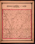
Title: |
Map of Township 26 South Range 1 East. Of the 6th Principal Meridian. Scale: 2 inches to 1 mile.
|
| Contributor: |
Edwards, John P.
|
| Creator: |
Special Collections and University Archives, WSU Libraries
|
| Subject: |
Sedgwick County (Kan.) -- Maps
|
| Date Created: |
1882
|
| Date Issued: |
2006
|
| Type: |
image
|
| Description: |
Map of Township 26 South Range 1 East, Sedgwick County, Kansas. Page 21 of 1882 Historical Atlas of Sedgwick County, Kansas. Shows north boundary line of the Osage Indian Lands. Shows Little Arkansas River, Chisholm Creek, mill race and springs. Also
A PDF version is available for downloading and printing.
Current name: Kechi Township.
|
|
Identifier: |
images/atlas_access/t26s.r1e.21.jpg
|
|
|
|
|