|
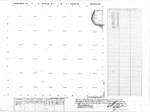
Title: |
Township No. 27 S Range No. 1 W 6th Principal Meridian
|
| Contributor: |
Surveyor General's Office
|
| Creator: |
Special Collections and University Archives, WSU Libraries
|
| Subject: |
Public lands -- Kansas -- Maps, manuscript
|
| Date Created: |
1867
|
| Date Issued: |
2005
|
| Type: |
image
|
| Description: |
Map of Township 27 South Range 1 West of the 6th Principal Meridian.
A PDF version is available for downloading and printing.
Current name: Delano Township.
|
|
Identifier: |
images/survey_access/t27s-r1w.1.jpg
|
|
|
|
|
|
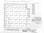
Title: |
Township No. XXVII South Range No. 1 West of the 6th Principal Meridian
|
| Contributor: |
Surveyor General's Office
|
| Creator: |
Special Collections and University Archives, WSU Libraries
|
| Subject: |
Public lands -- Kansas -- Maps, manuscript
|
| Date Created: |
1868
|
| Date Issued: |
2005
|
| Type: |
image
|
| Description: |
Map of Township 27 South Range 1 West of the 6th Principal Meridian. Shows Arkansas River, Cowskin Creek and unnamed creeks. Also noted are "Trail and Road from Salt Plains" and other unnamed trails.
A PDF version is available for downloading and printing.
Current name: Delano Township.
|
|
Identifier: |
images/survey_access/t27s-r1w.2.jpg
|
|
|
|
|

|
Title: |
Township No. 27 South Ranges No. 1 East & 1 West of 6th Principal Meridian Kan.
|
| Contributor: |
Surveyor General's Office
|
| Creator: |
Special Collections and University Archives, WSU Libraries
|
| Subject: |
Public lands -- Kansas -- Maps, manuscript
|
| Date Created: |
1875
|
| Date Issued: |
2005
|
| Type: |
image
|
| Description: |
Map of Townships 27 South Range 1 East and 27 South Range 1 West of the 6th Principal Meridian, Kansas. Survey of islands in sections 17 and 18, Township 27 South Range 1 East and section 13, Township 27 South Range 1 West.
A PDF version is available for downloading and printing.
Current name: Wichita Township.
|
|
Identifier: |
images/survey_access/t27s-r1e.4.jpg
|
|
|
|
|
|
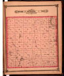
Title: |
Map of Township 27 South Range 1 West. Of the 6th Principal Meridian. Scale: 2 inches to 1 mile.
|
| Contributor: |
Edwards, John P.
|
| Creator: |
Special Collections and University Archives, WSU Libraries
|
| Subject: |
Sedgwick County (Kan.) -- Maps
|
| Date Created: |
1882
|
| Date Issued: |
2006
|
| Type: |
image
|
| Description: |
Map of Township 27 South Range 1 West, Sedgwick County, Kansas. Page 39 of 1882 Historical Atlas of Sedgwick County, Kansas. Eastern boundary labeled as 6th Principal Meridian. Shows Arkansas River, Cowskin Creek and Big Slough. Shows wind mills, ceme
A PDF version is available for downloading and printing.
Current name: Delano Township.
|
|
Identifier: |
images/atlas_access/t27s.r1w.39.jpg
|
|
|
|
|