
|
Title: |
Township No. 28 S Range No. 1 E 6th Principal Meridian
|
| Contributor: |
Surveyor General's Office
|
| Creator: |
Special Collections and University Archives, WSU Libraries
|
| Subject: |
Public lands -- Kansas -- Maps, manuscript
|
| Date Created: |
1867
|
| Date Issued: |
2005
|
| Type: |
image
|
| Description: |
Map of Township 28 South Range 1 East of the 6th Principal Meridian. Shows Arkansas River and unnamed creeks.
A PDF version is available for downloading and printing.
Current name: Riverside Township.
|
|
Identifier: |
images/survey_access/t28s-r1e.1.jpg
|
|
|
|
|

|
Title: |
Township No. XXVIII South Range No. 1 East of the 6th Principal Meridian Kansas
|
| Contributor: |
Surveyor General's Office
|
| Creator: |
Special Collections and University Archives, WSU Libraries
|
| Subject: |
Public lands -- Kansas -- Maps, manuscript
|
| Date Created: |
1868
|
| Date Issued: |
2005
|
| Type: |
image
|
| Description: |
Map of Township 28 South Range 1 East of the 6th Principal Meridian. Shows Arkansas River.
A PDF version is available for downloading and printing.
Current name: Riverside Township.
|
|
Identifier: |
images/survey_access/t28s-r1e.2.jpg
|
|
|
|
|
|
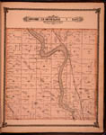
Title: |
Map of Township 28 South Range 1 East. Of the 6th Principal Meridian. Scale: 2 inches to 1 mile.
|
| Contributor: |
Edwards, John P.
|
| Creator: |
Special Collections and University Archives, WSU Libraries
|
| Subject: |
Sedgwick County (Kan.) -- Maps
|
| Date Created: |
1882
|
| Date Issued: |
2006
|
| Type: |
image
|
| Description: |
Map of Township 28 South Range 1 East, Sedgwick County, Kansas. Page 25 of 1882 Historical Atlas of Sedgwick County, Kansas. Shows Arkansas River, Cowskin Creek, Gypsum Creek, Chisholm Creek and Big Slough. Shows Atchison, Topeka and Santa Fe Railroad.
A PDF version is available for downloading and printing.
Current name: Riverside Township.
|
|
Identifier: |
images/atlas_access/t28s.r1e.25.jpg
|
|
|
|
|