
|
Title: |
Saint Mark Scale 500 Feet - 1 Inch / Mount Hope Scale 500 Feet - 1 Inch / Derby Scale 500 Ft. - 1 Inch / Marshall Scale 500 Ft - 1 Inch / Valley Center Scale 500 Ft - 1 Inch / Germania Scale 500 Ft - 1 Inch
|
| Creator: |
Edwards, John P.
|
| Source: |
Historical Atlas of Sedgwick County, Kansas
|
| Repository: |
Special Collections and University Archives, WSU Libraries
|
| Subject: |
Sedgwick County (Kan.) -- Maps
|
| Original Date: |
1882
|
| Digital Date: |
2006
|
| Description: |
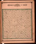
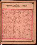
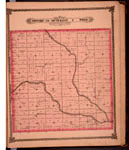
Maps, Saint Mark, Mount Hope, Derby, Marshall, Valley Center and Germania. Page 47 of 1882 Historical Atlas of Sedgwick County, Kansas. Plat maps of six towns show subdivisions, residences and other structures, property divisions, names of land owners, street names, roads, railroads, cemetery and rivers.
Current name: Saint Mark (St. Mark), Mount Hope (Mt. Hope), Derby, Marshall, Germania, Valley.
|
|
Print Version: |
A PDF version is available for downloading and printing.
|
|
Identifier: |
images/atlas_access/Saint_Mark.Mount_Hope.Derby.Marshall.Valley_Center.Germania.47.jpg
|
|
|
|
|
|
Title: |
Map of Township 28 South Range 2 West. Of the 6th Principal Meridian. Scale: 2 inches to 1 mile.
|
| Creator: |
Edwards, John P.
|
| Source: |
Historical Atlas of Sedgwick County, Kansas
|
| Repository: |
Special Collections and University Archives, WSU Libraries
|
| Subject: |
Sedgwick County (Kan.) -- Maps
|
| Original Date: |
1882
|
| Digital Date: |
2006
|
| Description: |
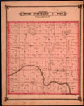
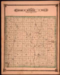
Map of Township 28 South Range 2 West, Sedgwick County, Kansas. Page 49 of 1882 Historical Atlas of Sedgwick County, Kansas. Shows Dry Creek, Afton Creek, Spring Creek and unnamed creeks. Also noted is Ruby post office. Shows schools, church, stone quarry, springs, blacksmith shop, roads, residences and other structures, property divisions and names of land owners.
Current name: Illinois Township.
|
|
Print Version: |
A PDF version is available for downloading and printing.
|
|
Identifier: |
images/atlas_access/t28s.r2w.49.jpg
|
|
|
|
|
|
Title: |
Map of Township 29 South Range 2 West. Of the 6th Principal Meridian. Scale: 2 inches to 1 mile.
|
| Creator: |
Edwards, John P.
|
| Source: |
Historical Atlas of Sedgwick County, Kansas
|
| Repository: |
Special Collections and University Archives, WSU Libraries
|
| Subject: |
Sedgwick County (Kan.) -- Maps
|
| Original Date: |
1882
|
| Digital Date: |
2006
|
| Description: |
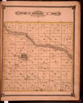
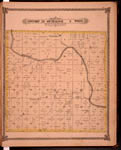
Map of Township 29 South Range 2 West, Sedgwick County, Kansas. Page 50 of 1882 Historical Atlas of Sedgwick County, Kansas. Shows Ninnescah River, Spring Creek and named fords on Ninnescah River. Shows Clearwater and Good River post offices. Also noted in section 11 is "Race Park." Southern boundary labeled Sumner County line. Shows stone quarries, wind mill, cattle shed, roads, residences and other structures, property divisions and names of land owners.
Current name: Ninnescah Township.
|
|
Print Version: |
A PDF version is available for downloading and printing.
|
|
Identifier: |
images/atlas_access/t29s.r2w.50.jpg
|
|
|
|
|
|
Title: |
Map of Township 25 South Range 3 West. Of the 6th Principal Meridian. Scale: 2 inches to 1 mile.
|
| Creator: |
Edwards, John P.
|
| Source: |
Historical Atlas of Sedgwick County, Kansas
|
| Repository: |
Special Collections and University Archives, WSU Libraries
|
| Subject: |
Sedgwick County (Kan.) -- Maps
|
| Original Date: |
1882
|
| Digital Date: |
2006
|
| Description: |
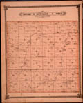
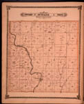
Map of Township 25 South Range 3 West, Sedgwick County, Kansas. Page 51 of 1882 Historical Atlas of Sedgwick County, Kansas. Shows schools, roads, residences and other structures, blacksmith shop, property divisions and names of land owners. Shows Arkansas River, Slough and springs. Also noted are town of Mount Hope and Fayette post office. Northern boundary labeled as Harvey County line. Western boundary labeled as Reno County line.
Current name: Greeley Township.
|
|
Print Version: |
A PDF version is available for downloading and printing.
|
|
Identifier: |
images/atlas_access/t25s.r3w.51.jpg
|
|
|
|
|
|
Title: |
Map of Township 26 South Range 3 West. Of the 6th Principal Meridian. Scale: 2 inches to 1 mile.
|
| Creator: |
Edwards, John P.
|
| Source: |
Historical Atlas of Sedgwick County, Kansas
|
| Repository: |
Special Collections and University Archives, WSU Libraries
|
| Subject: |
Sedgwick County (Kan.) -- Maps
|
| Original Date: |
1882
|
| Digital Date: |
2006
|
| Description: |
Map of Township 26 South Range 3 West, Sedgwick County, Kansas. Page 52 of 1882 Historical Atlas of Sedgwick County, Kansas. Shows north boundary line of Osage Indian Lands. Shows Slough and Cowskin Creek. Also noted is town of Germania and Magnolia post office. Western boundary is Reno County line. Shows blacksmith shop, sugar factory, walnut tree grove, cave, roads, residences and other structures, property division and names of land owners.
Current name: Sherman Township.
|
|
Print Version: |
A PDF version is available for downloading and printing.
|
|
Identifier: |
images/atlas_access/t26s.r3w.52.jpg
|
|
|
|
|
|
Title: |
Map of Township 27 South Range 3 West. Of the 6th Principal Meridian. Scale: 2 inches to 1 mile.
|
| Creator: |
Edwards, John P.
|
| Source: |
Historical Atlas of Sedgwick County, Kansas
|
| Repository: |
Special Collections and University Archives, WSU Libraries
|
| Subject: |
Sedgwick County (Kan.) -- Maps
|
| Original Date: |
1882
|
| Digital Date: |
2006
|
| Description: |
Map of Township 27 South Range 3 West, Sedgwick County, Kansas. Page 53 of 1882 Historical Atlas of Sedgwick County, Kansas. Shows town of Germania and Lamont post office. Shows Clear Creek, Pole Cat Creek and unnamed creeks. Also noted are schools, cemetery, wind mill, roads, residences and other structures, property divisions and names of land owners.
Current name: Garden Plain Township.
|
|
Print Version: |
A PDF version is available for downloading and printing.
|
|
Identifier: |
images/atlas_access/t27s.r3w.53.jpg
|
|
|
|
|
|
Title: |
Map of Township 28 South Range 3 West. Of the 6th Principal Meridian. Scale: 2 inches to 1 mile.
|
| Creator: |
Edwards, John P.
|
| Source: |
Historical Atlas of Sedgwick County, Kansas
|
| Repository: |
Special Collections and University Archives, WSU Libraries
|
| Subject: |
Sedgwick County (Kan.) -- Maps
|
| Original Date: |
1882
|
| Digital Date: |
2006
|
| Description: |
Map of Township 28 South Range 3 West, Sedgwick County, Kansas. Page 54 of 1882 Historical Atlas of Sedgwick County, Kansas. Shows Ninnescah River and middle and east branches of Clearwater Creek. Afton post office is noted. Shows springs, stone quarries. cemetery, schools, blacksmith shop, roads, residences and other structures, property divisions and names of land owners.
Current name: Afton Township.
|
|
Print Version: |
A PDF version is available for downloading and printing.
|
|
Identifier: |
images/atlas_access/t28s.r3w.54.jpg
|
|
|
|
|
|
Title: |
Map of Township 29 South Range 3 West. Of the 6th Principal Meridian. Scale: 2 inches to 1 mile.
|
| Creator: |
Edwards, John P.
|
| Source: |
Historical Atlas of Sedgwick County, Kansas
|
| Repository: |
Special Collections and University Archives, WSU Libraries
|
| Subject: |
Sedgwick County (Kan.) -- Maps
|
| Original Date: |
1882
|
| Digital Date: |
2006
|
| Description: |
Map of Township 29 South Range 3 West, Sedgwick County, Kansas. Page 55 of 1882 Historical Atlas of Sedgwick County, Kansas. Shows Ninnescah River, Clearwater Creek and unnamed creeks. Shows Coronado and Peotone post offices. Southern boundary labeled Sumner County line. Also noted are schools, cemeteries, wind mill, blacksmith shop, churches, roads, residences and other structures, property divisions and names of land owners.
Current name: Viola Township.
|
|
Print Version: |
A PDF version is available for downloading and printing.
|
|
Identifier: |
images/atlas_access/t29s.r3w.55.jpg
|
|
|
|
|
|
Title: |
Map of Township 27 South Range 4 West. Of the 6th Principal Meridian. Scale: 2 inches to 1 mile.
|
| Creator: |
Edwards, John P.
|
| Source: |
Historical Atlas of Sedgwick County, Kansas
|
| Repository: |
Special Collections and University Archives, WSU Libraries
|
| Subject: |
Sedgwick County (Kan.) -- Maps
|
| Original Date: |
1882
|
| Digital Date: |
2006
|
| Description: |
Map of Township 27 South Range 4 West, Sedgwick County, Kansas. Page 56 of 1882 Historical Atlas of Sedgwick County, Kansas. Shows Rock Creek, Sand Creek, Spring Creek and north fork of Ninnescah River. Shows town of Marshall and Birch post office. Northern boundary is Reno County line. Western boundary is Kingman County line. Also noted are schools, springs, roads, residences and other structures, property divisions and names of land owners.
Current name: Grand River Township.
|
|
Print Version: |
A PDF version is available for downloading and printing.
|
|
Identifier: |
images/atlas_access/t27s.r4w.56.jpg
|
|
|
|
|
|
Title: |
Map of Township 28 South Range 4 West. Of the 6th Principal Meridian. Scale: 2 inches to 1 mile.
|
| Creator: |
Edwards, John P.
|
| Source: |
Historical Atlas of Sedgwick County, Kansas
|
| Repository: |
Special Collections and University Archives, WSU Libraries
|
| Subject: |
Sedgwick County (Kan.) -- Maps
|
| Original Date: |
1882
|
| Digital Date: |
2006
|
| Description: |
Map of Township 28 South Range 4 West, Sedgwick County, Kansas. Page 57 of 1882 Historical Atlas of Sedgwick County, Kansas. Shows Ninnescah River, southwest fork of Ninnescah River, Mud Creek, Spring Creek and unnamed creeks. Western boundary labeled as Kingman County line. Shows Herald post office and Venice post office. Also noted are schools, lake, roads, residences and other structures, property divisions and names of land owners.
Current name: Morton Township.
|
|
Print Version: |
A PDF version is available for downloading and printing.
|
|
Identifier: |
images/atlas_access/t28s.r4w.57.jpg
|
|
|
|
|