|
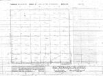
Title: |
Township No. 25 South Range No. 1 East of the 6th Principal Meridian - Kan. Ter.
|
| Contributor: |
Surveyor General's Office
|
| Creator: |
Special Collections and University Archives, WSU Libraries
|
| Subject: |
Public lands -- Kansas -- Maps, manuscript
|
| Date Created: |
1860
|
| Date Issued: |
2005
|
| Type: |
image
|
| Description: |
Map of Township 25 South Range 1 East of the 6th Principal Meridian, Kansas Territory. Shows unnamed creeks.
A PDF version is available for downloading and printing.
Current name: Grant Township.
|
|
Identifier: |
images/survey_access/t25s-r1e.jpg
|
|
|
|
|
|
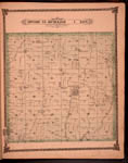
Title: |
Map of Township 25 South Range 1 East. Of the 6th Principal Meridian. Scale: 2 inches to 1 mile.
|
| Contributor: |
Edwards, John P.
|
| Creator: |
Special Collections and University Archives, WSU Libraries
|
| Subject: |
Sedgwick County (Kan.) -- Maps
|
| Date Created: |
1882
|
| Date Issued: |
2006
|
| Type: |
image
|
| Description: |
Map of Township 25 South Range 1 East, Sedgwick County, Kansas. Page 19 of 1882 Historical Atlas of Sedgwick County, Kansas. Shows Jester Creek, west and east branches of Chisholm Creek and unnamed creeks. Shows schools, cemeteries, churches, stone quar
A PDF version is available for downloading and printing.
Current name: Grant Township.
|
|
Identifier: |
images/atlas_access/t25s.r1e.19.jpg
|
|
|
|
|