|
Title: |
Township No. 26 South Range No. 3 West of the 6th Principal Meridian
|
| Contributor: |
Surveyor General's Office
|
| Creator: |
Special Collections and University Archives, WSU Libraries
|
| Subject: |
Public lands -- Kansas -- Maps, manuscript
|
| Date Created: |
1868
|
| Date Issued: |
2005
|
| Type: |
image
|
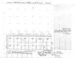
| Description: |
Map of Township 26 South Range 3 West of the 6th Principal Meridian. Shows 12 sections below northern boundary of Osage Indian Trust Lands (Osage Indian Lands). Shows Dry Creek and unnamed creeks.
A PDF version is available for downloading and printing.
Current name: Sherman Township.
|
|
Identifier: |
images/survey_access/t26s-r3w.2.jpg
|
|
|
|
|
|
Title: |
Township No. 26 South Range No. 3 West of 6. Principal Meridian Kansas
|
| Contributor: |
Surveyor General's Office
|
| Creator: |
Special Collections and University Archives, WSU Libraries
|
| Subject: |
Public lands -- Kansas -- Maps, manuscript
|
| Date Created: |
1871
|
| Date Issued: |
2005
|
| Type: |
image
|
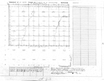
| Description: |
Map of Township 26 South Range 3 West of the 6th Principal Meridian, Kansas. Shows 24 sections above northern boundary of Osage Ceded Lands (Osage Indian Lands). Shows Cowskin Creek and unnamed creeks and ravines.
A PDF version is available for downloading and printing.
Current name: Sherman Township.
|
|
Identifier: |
images/survey_access/t26s-r3w.1.jpg
|
|
|
|
|
|
Title: |
Map of Township 26 South Range 3 West. Of the 6th Principal Meridian. Scale: 2 inches to 1 mile.
|
| Contributor: |
Edwards, John P.
|
| Creator: |
Special Collections and University Archives, WSU Libraries
|
| Subject: |
Sedgwick County (Kan.) -- Maps
|
| Date Created: |
1882
|
| Date Issued: |
2006
|
| Type: |
image
|
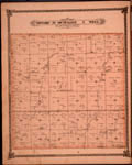
| Description: |
Map of Township 26 South Range 3 West, Sedgwick County, Kansas. Page 52 of 1882 Historical Atlas of Sedgwick County, Kansas. Shows north boundary line of Osage Indian Lands. Shows Slough and Cowskin Creek. Also noted is town of Germania and Magnolia p
A PDF version is available for downloading and printing.
Current name: Sherman Township.
|
|
Identifier: |
images/atlas_access/t26s.r3w.52.jpg
|
|
|
|
|