|
Title: |
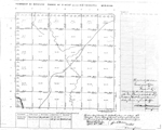
Township No. 28 South Range No. 3 West of the 6th Principal Meridian.
|
| Contributor: |
Surveyor General's Office
|
| Creator: |
Special Collections and University Archives, WSU Libraries
|
| Subject: |
Public lands -- Kansas -- Maps, manuscript
|
| Date Created: |
1868
|
| Date Issued: |
2005
|
| Type: |
image
|
| Description: |
Map of Township 28 South Range 3 West of the 6th Principal Meridian. Shows "Ne-Ne Squaw" River (Ninnescah River) and unnamed creeks. Also identified is "Trail to Salt Plains."
A PDF version is available for downloading and printing.
Current name: Afton Township.
|
|
Identifier: |
images/survey_access/t28s-r3w.1.jpg
|
|
|
|
|
|
Title: |
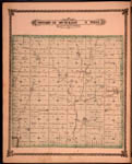
Map of Township 28 South Range 3 West. Of the 6th Principal Meridian. Scale: 2 inches to 1 mile.
|
| Contributor: |
Edwards, John P.
|
| Creator: |
Special Collections and University Archives, WSU Libraries
|
| Subject: |
Sedgwick County (Kan.) -- Maps
|
| Date Created: |
1882
|
| Date Issued: |
2006
|
| Type: |
image
|
| Description: |
Map of Township 28 South Range 3 West, Sedgwick County, Kansas. Page 54 of 1882 Historical Atlas of Sedgwick County, Kansas. Shows Ninnescah River and middle and east branches of Clearwater Creek. Afton post office is noted. Shows springs, stone quarr
A PDF version is available for downloading and printing.
Current name: Afton Township.
|
|
Identifier: |
images/atlas_access/t28s.r3w.54.jpg
|
|
|
|
|