|
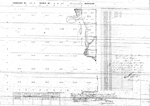
Title: |
Township No. 29 South Range No. 1 East 6th Principal Meridian.
|
| Contributor: |
Surveyor General's Office
|
| Creator: |
Special Collections and University Archives, WSU Libraries
|
| Subject: |
Public lands -- Kansas -- Maps, manuscript
|
| Date Created: |
1867
|
| Date Issued: |
2005
|
| Type: |
image
|
| Description: |
Map of Township 29 South Range 1 East of the 6th Principal Meridian, Kansas.
A PDF version is available for downloading and printing.
Current name: Salem Township.
|
|
Identifier: |
images/survey_access/t29s-r1e.1.jpg
|
|
|
|
|
|
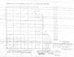
Title: |
Township No. 29 South Range No. 1 East of the 6 Principal Meridian
|
| Contributor: |
Surveyor General's Office
|
| Creator: |
Special Collections and University Archives, WSU Libraries
|
| Subject: |
Public lands -- Kansas -- Maps, manuscript
|
| Date Created: |
1868
|
| Date Issued: |
2005
|
| Type: |
image
|
| Description: |
Map of Township 29 South Range 1 East of the 6th Principal Meridian, Kansas. Shows Arkansas River, Cowskin Creek and unnamed creek..
A PDF version is available for downloading and printing.
Current name: Salem Township.
|
|
Identifier: |
images/survey_access/t29s-r1e.4.jpg
|
|
|
|
|
|
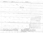
Title: |
Township No. 29 South Range No. 1 East of 6th Principal Meridian Kan.
|
| Contributor: |
Surveyor General's Office
|
| Creator: |
Special Collections and University Archives, WSU Libraries
|
| Subject: |
Public lands -- Kansas -- Maps, manuscript
|
| Date Created: |
1875
|
| Date Issued: |
2005
|
| Type: |
image
|
| Description: |
Map of Township 29 South Range 1 East of the 6th Principal Meridian, Kansas. Shows island in Arkansas River in sections 2 and 3.
A PDF version is available for downloading and printing.
Current name: Salem Township.
|
|
Identifier: |
images/survey_access/t29s-r1e.2.jpg
|
|
|
|
|
|
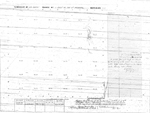
Title: |
Township No. 29 South Range No. 1 East of the 6th Principal Meridian Kan
|
| Contributor: |
Surveyor General's Office
|
| Creator: |
Special Collections and University Archives, WSU Libraries
|
| Subject: |
Public lands -- Kansas -- Maps, manuscript
|
| Date Created: |
1876
|
| Date Issued: |
2005
|
| Type: |
image
|
| Description: |
Map of Township 29 South Range 1 East of the 6th Principal Meridian, Kansas. Shows island in Arkansas River in section 12.
A PDF version is available for downloading and printing.
Current name: Salem Township.
|
|
Identifier: |
images/survey_access/t29s-r1e.3.jpg
|
|
|
|
|
|
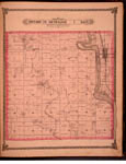
Title: |
Map of Township 29 South Range 1 East. Of the 6th Principal Meridian. Scale: 2 inches to 1 mile.
|
| Contributor: |
Edwards, John P.
|
| Creator: |
Special Collections and University Archives, WSU Libraries
|
| Subject: |
Sedgwick County (Kan.) -- Maps
|
| Date Created: |
1882
|
| Date Issued: |
2006
|
| Type: |
image
|
| Description: |
Map of Township 29 South Range 1 East, Sedgwick County, Kansas. Page 27 of 1882 Historical Atlas of Sedgwick County, Kansas. Shows Arkansas River, Cowskin Creek and Spring Creek. Show town of Derby and Haysville and Waco post offices. Southern boundar
A PDF version is available for downloading and printing.
Current name: Salem Township.
|
|
Identifier: |
images/atlas_access/t29s.r1e.27.jpg
|
|
|
|
|