|
Title: |
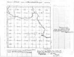
Township No. 29 S. Range No. 3 West of the 6th Principal Meridian
|
| Contributor: |
Surveyor General's Office
|
| Creator: |
Special Collections and University Archives, WSU Libraries
|
| Subject: |
Public lands -- Kansas -- Maps, manuscript
|
| Date Created: |
1868
|
| Date Issued: |
2005
|
| Type: |
image
|
| Description: |
Map of Township 29 South Range 3 West of the 6th Principal Meridian. Shows "Ne-Ne Squaw" River (Ninnescah River) and unnamed creeks. Shows trail identified as "Trail to Salt Plains."
A PDF version is available for downloading and printing.
Current name: Viola Township.
|
|
Identifier: |
images/survey_access/t29s-r3w.1.jpg
|
|
|
|
|
|
Title: |
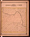
Map of Township 29 South Range 3 West. Of the 6th Principal Meridian. Scale: 2 inches to 1 mile.
|
| Contributor: |
Edwards, John P.
|
| Creator: |
Special Collections and University Archives, WSU Libraries
|
| Subject: |
Sedgwick County (Kan.) -- Maps
|
| Date Created: |
1882
|
| Date Issued: |
2006
|
| Type: |
image
|
| Description: |
Map of Township 29 South Range 3 West, Sedgwick County, Kansas. Page 55 of 1882 Historical Atlas of Sedgwick County, Kansas. Shows Ninnescah River, Clearwater Creek and unnamed creeks. Shows Coronado and Peotone post offices. Southern boundary labeled
A PDF version is available for downloading and printing.
Current name: Viola Township.
|
|
Identifier: |
images/atlas_access/t29s.r3w.55.jpg
|
|
|
|
|