
|
Title: |
TP. No. 27, S. R. No. 1. E. 6th Pl. Mdn. Kas.
|
| Contributor: |
Surveyor General's Office
|
| Creator: |
Special Collections and University Archives, WSU Libraries
|
| Subject: |
Public lands -- Kansas -- Maps, manuscript
|
| Date Created: |
1867
|
| Date Issued: |
2005
|
| Type: |
image
|
| Description: |
Map of Township 27 South Range 1 East of the 6th Principal Meridian, Kansas. Survey of sections east of Arkansas River only. Shows Indian Trading Post in section 7 and section 9. Shows unnamed trail. Also noted is Indian encampment, sections 8 and 17.
A PDF version is available for downloading and printing.
Current name: Wichita Township.
|
|
Identifier: |
images/survey_access/t27s-r1e.6.jpg
|
|
|
|
|

|
Title: |
Township No. XXVII South Range No. 1 East of the 6th Principal Meridian Kansas
|
| Contributor: |
Surveyor General's Office
|
| Creator: |
Special Collections and University Archives, WSU Libraries
|
| Subject: |
Public lands -- Kansas -- Maps, manuscript
|
| Date Created: |
1868
|
| Date Issued: |
2005
|
| Type: |
image
|
| Description: |
Map of Township 27 South Range 1 East of the 6th Principal Meridian, Kansas. Survey of sections west of Arkansas River only. Shows west bank of Arkansas River and location of ford. Shows unnamed trail.
A PDF version is available for downloading and printing.
Current name: Wichita Township.
|
|
Identifier: |
images/survey_access/t27s-r1e.7.jpg
|
|
|
|
|

|
Title: |
Township No. 27 South Range No. 1 East of the 6th Principl Meridian Kan.
|
| Contributor: |
Surveyor General's Office
|
| Creator: |
Special Collections and University Archives, WSU Libraries
|
| Subject: |
Public lands -- Kansas -- Maps, manuscript
|
| Date Created: |
1874
|
| Date Issued: |
2005
|
| Type: |
image
|
| Description: |
Map of Township 27 South Range 1 East of the 6th Principal Meridian, Kansas. Survey of sections 29 and 32 only. Shows two islands in the Arkansas River.
A PDF version is available for downloading and printing.
Current name: Wichita Township.
|
|
Identifier: |
images/survey_access/t27s-r1e.5.jpg
|
|
|
|
|

|
Title: |
Township No. 27 South Ranges No. 1 East & 1 West of 6th Principal Meridian Kan.
|
| Contributor: |
Surveyor General's Office
|
| Creator: |
Special Collections and University Archives, WSU Libraries
|
| Subject: |
Public lands -- Kansas -- Maps, manuscript
|
| Date Created: |
1875
|
| Date Issued: |
2005
|
| Type: |
image
|
| Description: |
Map of Townships 27 South Range 1 East and 27 South Range 1 West of the 6th Principal Meridian, Kansas. Survey of islands in sections 17 and 18, Township 27 South Range 1 East and section 13, Township 27 South Range 1 West.
A PDF version is available for downloading and printing.
Current name: Delano Township.
|
|
Identifier: |
images/survey_access/t27s-r1e.4.jpg
|
|
|
|
|
|
Title: |
Map of Township 27 South Range 1 East. Of the 6th Principal Meridian. Scale: 2 inches to 1 mile.
|
| Contributor: |
Edwards, John P.
|
| Creator: |
Special Collections and University Archives, WSU Libraries
|
| Subject: |
Sedgwick County (Kan.) -- Maps
|
| Date Created: |
1882
|
| Date Issued: |
2006
|
| Type: |
image
|
| Description: |
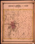
Map of Township 27 South Range 1 East, Sedgwick County, Kansas. Page 22 of 1882 Historical Atlas of Sedgwick County, Kansas. Shows city of Wichita. Shows Arkansas River and islands, Little Arkansas River, Chisholm Creek and Dry Creek. Shows Atchison,
A PDF version is available for downloading and printing.
Current name: Wichita Township.
|
|
Identifier: |
images/atlas_access/t27s.r1e.22.jpg
|
|
|
|
|
|
Title: |
Edwards Map of the City of Wichita Kansas. Scale 500 feet to the Inch. 1882.
|
| Contributor: |
Edwards, John P.
|
| Creator: |
Special Collections and University Archives, WSU Libraries
|
| Subject: |
Wichita (Kan.) -- Maps
|
| Date Created: |
1882
|
| Date Issued: |
2005
|
| Type: |
image
|
| Description: |
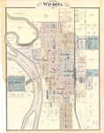
Map, Wichita, Kansas. Page 23 of 1882 Historical Atlas of Sedgwick County, Kansas. Plat map shows subdivisions, residences and some named structures, property divisions, names of land owners, street names, roads, railroads, rivers, islands, bridges, wards
A PDF version is available for downloading and printing.
Current name: Wichita City Map.
|
|
Identifier: |
images/atlas_access/wichita.23.jpg
|
|
|
|
|

|
Title: |
Plat of an Island in Arkansas River, Sec.20, T. 27 S. R. 1 E. 6th P. M. State of Kansas
|
| Contributor: |
Surveyor General's Office
|
| Creator: |
Special Collections and University Archives, WSU Libraries
|
| Subject: |
Public lands -- Kansas -- Maps, manuscript
|
| Date Created: |
1884
|
| Date Issued: |
2005
|
| Type: |
image
|
| Description: |
Map of Township 27 South Range 1 East of the 6th Principal Meridian, Kansas; Scale: 4 chains to an inch. Plat of an island in the Arkansas River in section 20.
A PDF version is available for downloading and printing.
Current name: Wichita Township.
|
|
Identifier: |
images/survey_access/t27s-r1e.3.jpg
|
|
|
|
|

|
Title: |
Township No. XXVII South Range 1 East
|
| Contributor: |
Surveyor General's Office
|
| Creator: |
Special Collections and University Archives, WSU Libraries
|
| Subject: |
Public lands -- Kansas -- Maps, manuscript
|
| Date Created: |
1884
|
| Date Issued: |
2005
|
| Type: |
image
|
| Description: |
Map of Township 27 South Range 1 East of the 6th Principal Meridian. Plat of an island in the Arkansas River in section 20.
A PDF version is available for downloading and printing.
Current name: Wichita Township.
|
|
Identifier: |
images/survey_access/t27s-r1e.1.jpg
|
|
|
|
|

|
Title: |
Plat of an Island in Arkansas River. Section 20.T.27.S.R.1.E.6th P.M. State of Kansas. Scale 4 chains to an inch.
|
| Contributor: |
Surveyor General's Office
|
| Creator: |
Special Collections and University Archives, WSU Libraries
|
| Subject: |
Public lands -- Kansas -- Maps, manuscript
|
| Date Created: |
1888
|
| Date Issued: |
2005
|
| Type: |
image
|
| Description: |
Map of Township 27 South Range 1 East of the 6th Principal Meridian, Kansas; Scale: 4 chains to an inch.
A PDF version is available for downloading and printing.
Current name: Wichita Township.
|
|
Identifier: |
images/survey_access/t27s-r1e.2.jpg
|
|
|
|
|