|
Title: |
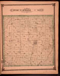
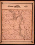
Map of Township 25 South Range 1 East. Of the 6th Principal Meridian. Scale: 2 inches to 1 mile.
|
| Creator: |
Edwards, John P.
|
| Source: |
Historical Atlas of Sedgwick County, Kansas
|
| Repository: |
Special Collections and University Archives, WSU Libraries
|
| Subject: |
Sedgwick County (Kan.) -- Maps
|
| Original Date: |
1882
|
| Digital Date: |
2006
|
| Description: |
Map of Township 25 South Range 1 East, Sedgwick County, Kansas. Page 19 of 1882 Historical Atlas of Sedgwick County, Kansas. Shows Jester Creek, west and east branches of Chisholm Creek and unnamed creeks. Shows schools, cemeteries, churches, stone quarry, blacksmith shop, roads, residences and other structures, property divisions and names of land owners. Also noted is Sunny Dale post office. Northern boundary identified as Harvey County line. Eastern boundary identified as Butler County line.
Current name: Grant Township.
|
|
Print Version: |
A PDF version is available for downloading and printing.
|
|
Identifier: |
images/atlas_access/t25s.r1e.19.jpg
|
|
|
|
|
|
Title: |
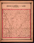
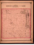
Map of Township 26 South Range 1 East. Of the 6th Principal Meridian. Scale: 2 inches to 1 mile.
|
| Creator: |
Edwards, John P.
|
| Source: |
Historical Atlas of Sedgwick County, Kansas
|
| Repository: |
Special Collections and University Archives, WSU Libraries
|
| Subject: |
Sedgwick County (Kan.) -- Maps
|
| Original Date: |
1882
|
| Digital Date: |
2006
|
| Description: |
Map of Township 26 South Range 1 East, Sedgwick County, Kansas. Page 21 of 1882 Historical Atlas of Sedgwick County, Kansas. Shows north boundary line of the Osage Indian Lands. Shows Little Arkansas River, Chisholm Creek, mill race and springs. Also noted are roads, residences and other structures, wind grist mill, ice house, cemetery, stone quarry, property divisions and names of land owners.
Current name: Kechi Township.
|
|
Print Version: |
A PDF version is available for downloading and printing.
|
|
Identifier: |
images/atlas_access/t26s.r1e.21.jpg
|
|
|
|
|
|
Title: |
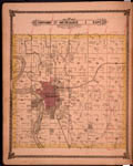
Map of Township 27 South Range 1 East. Of the 6th Principal Meridian. Scale: 2 inches to 1 mile.
|
| Creator: |
Edwards, John P.
|
| Source: |
Historical Atlas of Sedgwick County, Kansas
|
| Repository: |
Special Collections and University Archives, WSU Libraries
|
| Subject: |
Sedgwick County (Kan.) -- Maps
|
| Original Date: |
1882
|
| Digital Date: |
2006
|
| Description: |
Map of Township 27 South Range 1 East, Sedgwick County, Kansas. Page 22 of 1882 Historical Atlas of Sedgwick County, Kansas. Shows city of Wichita. Shows Arkansas River and islands, Little Arkansas River, Chisholm Creek and Dry Creek. Shows Atchison, Topeka and Santa Fe railroad and St. Louis-San Francisco railroad. Also noted are schools, cemetery, wind mill, slaughter house, fairgrounds, iron works, water mill, roads, residences and other structures, property divisions and names of land owners. Western boundary labeled as 6th Principal Meridian.
Current name: Wichita Township.
|
|
Print Version: |
A PDF version is available for downloading and printing.
|
|
Identifier: |
images/atlas_access/t27s.r1e.22.jpg
|
|
|
|
|
|
Title: |
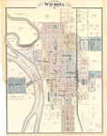
Edwards Map of the City of Wichita Kansas. Scale 500 feet to the Inch. 1882.
|
| Creator: |
Edwards, John P.
|
| Source: |
Historical Atlas of Sedgwick County, Kansas
|
| Repository: |
Special Collections and University Archives, WSU Libraries
|
| Subject: |
Wichita (Kan.) -- Maps
|
| Original Date: |
1882
|
| Digital Date: |
2005
|
| Description: |
Map, Wichita, Kansas. Page 23 of 1882 Historical Atlas of Sedgwick County, Kansas. Plat map shows subdivisions, residences and some named structures, property divisions, names of land owners, street names, roads, railroads, rivers, islands, bridges, wards and corporation lines (city limits).
Current name: Wichita City Map.
|
|
Print Version: |
A PDF version is available for downloading and printing.
|
|
Identifier: |
images/atlas_access/wichita.23.jpg
|
|
|
|
|
|
Title: |
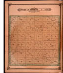
Map of Township 28 South Range 1 East. Of the 6th Principal Meridian. Scale: 2 inches to 1 mile.
|
| Creator: |
Edwards, John P.
|
| Source: |
Historical Atlas of Sedgwick County, Kansas
|
| Repository: |
Special Collections and University Archives, WSU Libraries
|
| Subject: |
Sedgwick County (Kan.) -- Maps
|
| Original Date: |
1882
|
| Digital Date: |
2006
|
| Description: |
Map of Township 28 South Range 1 East, Sedgwick County, Kansas. Page 25 of 1882 Historical Atlas of Sedgwick County, Kansas. Shows Arkansas River, Cowskin Creek, Gypsum Creek, Chisholm Creek and Big Slough. Shows Atchison, Topeka and Santa Fe Railroad. Also noted are schools, roads, residences and other structures, property divisions and names of land owners. Western boundary labeled as 6th Principal Meridian.
Current name: Riverside Township.
|
|
Print Version: |
A PDF version is available for downloading and printing.
|
|
Identifier: |
images/atlas_access/t28s.r1e.25.jpg
|
|
|
|
|
|
Title: |
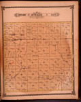
Map of Township 29 South Range 1 East. Of the 6th Principal Meridian. Scale: 2 inches to 1 mile.
|
| Creator: |
Edwards, John P.
|
| Source: |
Historical Atlas of Sedgwick County, Kansas
|
| Repository: |
Special Collections and University Archives, WSU Libraries
|
| Subject: |
Sedgwick County (Kan.) -- Maps
|
| Original Date: |
1882
|
| Digital Date: |
2006
|
| Description: |
Map of Township 29 South Range 1 East, Sedgwick County, Kansas. Page 27 of 1882 Historical Atlas of Sedgwick County, Kansas. Shows Arkansas River, Cowskin Creek and Spring Creek. Show town of Derby and Haysville and Waco post offices. Southern boundary is labeled as Sumner County line. Also noted are wind mills, fish pond, cemeteries, roads, residences and other structures, property divisions and names of land owners. Western boundary labeled as 6th Principal Meridian.
Current name: Salem Township.
|
|
Print Version: |
A PDF version is available for downloading and printing.
|
|
Identifier: |
images/atlas_access/t29s.r1e.27.jpg
|
|
|
|
|

|
Title: |
Map of Township 25 South Range 2 East. Of the 6th Principal Meridian. Scale: 2 inches to 1 mile.
|
| Creator: |
Edwards, John P.
|
| Source: |
Historical Atlas of Sedgwick County, Kansas
|
| Repository: |
Special Collections and University Archives, WSU Libraries
|
| Subject: |
Sedgwick County (Kan.) -- Maps
|
| Original Date: |
1882
|
| Digital Date: |
2006
|
| Description: |
Map of Township 25 South Range 2 East, Sedgwick County, Kansas. Page 29 of 1882 Historical Atlas of Sedgwick County, Kansas. Plat map shows gypsum and stone quarries, schools, cemetery, springs, roads, residences and other structures, property divisions and names of land owners. Also noted are Edgecomb and Clarion post offices. Northern boundary identified as Harvey County line. Eastern boundary identified as Butler County line. Shows Wild Cat Creek, Prairie Branch and unnamed creeks.
Current name: Lincoln Township.
|
|
Print Version: |
A PDF version is available for downloading and printing.
|
|
Identifier: |
images/atlas_access/t25s.r2e.29.jpg
|
|
|
|
|
|
Title: |
Map of Township 26 South Range 2 East. Of the 6th Principal Meridian. Scale: 2 inches to 1 mile.
|
| Creator: |
Edwards, John P.
|
| Source: |
Historical Atlas of Sedgwick County, Kansas
|
| Repository: |
Special Collections and University Archives, WSU Libraries
|
| Subject: |
Sedgwick County (Kan.) -- Maps
|
| Original Date: |
1882
|
| Digital Date: |
2006
|
| Description: |
Map of Township 26 South Range 2 East, Sedgwick County, Kansas. Page 30 of 1882 Historical Atlas of Sedgwick County, Kansas. Shows Greenwich post office approximately 1.25 miles directly east of current Greenwich town site. Shows Indianola Creek, Dry Creek, east branch of Chisholm Creek, and north and south branches of Whitewater Creek. Shows schools, cemeteries, roads, residences and other structures, property divisions and names of land owners. Eastern boundary labeled as Butler County line. Shows north boundary of Osage Indian Lands.
Current name: Payne Township.
|
|
Print Version: |
A PDF version is available for downloading and printing.
|
|
Identifier: |
images/atlas_access/t26s.r2e.30.jpg
|
|
|
|
|
|
Title: |
Map of Township 27 South Range 2 East. Of the 6th Principal Meridian. Scale: 2 inches to 1 mile.
|
| Creator: |
Edwards, John P.
|
| Source: |
Historical Atlas of Sedgwick County, Kansas
|
| Repository: |
Special Collections and University Archives, WSU Libraries
|
| Subject: |
Sedgwick County (Kan.) -- Maps
|
| Original Date: |
1882
|
| Digital Date: |
2006
|
| Description: |
Map of Township 27 South Range 2 East, Sedgwick County, Kansas. Page 31 of 1882 Historical Atlas of Sedgwick County, Kansas. Shows Manchester Station along St. Louis-San Francisco railroad. Shows Gypsum Creek, Spring Creek, Four Mile Creek and unnamed creeks. Eastern boundary labeled as Butler County line. Also noted are schools, blacksmith shops, salt works, cemetery, roads, residences and other structures, property divisions and names of land owners.
Current name: Minneha Township.
|
|
Print Version: |
A PDF version is available for downloading and printing.
|
|
Identifier: |
images/atlas_access/t27s.r2e.31.jpg
|
|
|
|
|

|
Title: |
Map of Township 28 South Range 2 East. Of the 6th Principal Meridian. Scale: 2 inches to 1 mile.
|
| Creator: |
Edwards, John P.
|
| Source: |
Historical Atlas of Sedgwick County, Kansas
|
| Repository: |
Special Collections and University Archives, WSU Libraries
|
| Subject: |
Sedgwick County (Kan.) -- Maps
|
| Original Date: |
1882
|
| Digital Date: |
2006
|
| Description: |
Map of Township 28 South Range 2 East, Sedgwick County, Kansas. Page 33 of 1882 Historical Atlas of Sedgwick County, Kansas. Shows Spring Creek and unnamed creeks. Eastern boundary labeled as Butler County line. Shows Iowaville post office. Shows schools, roads, residences and other structures, property divisions and names of land owners.
Current name: Gypsum Township.
|
|
Print Version: |
A PDF version is available for downloading and printing.
|
|
Identifier: |
images/atlas_access/t28s.r2e.33.jpg
|
|
|
|
|