|
Title: |
Township No. 26 South Range No. 2 East of 6th Principal Meridian Kan. Ter.
|
| Contributor: |
Surveyor General's Office
|
| Creator: |
Special Collections and University Archives, WSU Libraries
|
| Subject: |
Public lands -- Kansas -- Maps, manuscript
|
| Date Created: |
1861
|
| Date Issued: |
2005
|
| Type: |
image
|
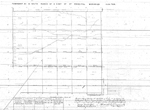
| Description: |
Map of Township 26 South Range 2 East of the 6th Principal Meridian, Kansas Territory. Shows 24 townships above north boundary of Osage Indian Land. Shows unnamed creek and trail.
A PDF version is available for downloading and printing.
Current name: Payne Township.
|
|
Identifier: |
images/survey_access/t26s-r2e.2.jpg
|
|
|
|
|
|
Title: |
Township No. 26 South Range No. 2 East 6th Principal Meridian Kansas
|
| Contributor: |
Surveyor General's Office
|
| Creator: |
Special Collections and University Archives, WSU Libraries
|
| Subject: |
Public lands -- Kansas -- Maps, manuscript
|
| Date Created: |
1867
|
| Date Issued: |
2005
|
| Type: |
image
|
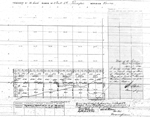
| Description: |
Map of Township 26 South Range 2 East of the 6th Principal Meridian, Kansas. Shows 12 sections below north boundary of Osage Indian Lands. Shows unnamed creeks and trail.
A PDF version is available for downloading and printing.
Current name: Payne Township.
|
|
Identifier: |
images/survey_access/t26s-r2e.1.jpg
|
|
|
|
|
|
Title: |
Map of Township 26 South Range 2 East. Of the 6th Principal Meridian. Scale: 2 inches to 1 mile.
|
| Contributor: |
Edwards, John P.
|
| Creator: |
Special Collections and University Archives, WSU Libraries
|
| Subject: |
Sedgwick County (Kan.) -- Maps
|
| Date Created: |
1882
|
| Date Issued: |
2006
|
| Type: |
image
|
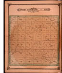
| Description: |
Map of Township 26 South Range 2 East, Sedgwick County, Kansas. Page 30 of 1882 Historical Atlas of Sedgwick County, Kansas. Shows Greenwich post office approximately 1.25 miles directly east of current Greenwich town site. Shows Indianola Creek, Dry C
A PDF version is available for downloading and printing.
Current name: Payne Township.
|
|
Identifier: |
images/atlas_access/t26s.r2e.30.jpg
|
|
|
|
|